

History of the B600 (Nottingham Road)
by SLHS on
Sunday 8 May 2016
The main highway from Alfreton through Somercotes and Pye Bridge did not always follow the same route that it does today. The original Alfreton-Nottingham Road ran via Flowery Leys Lane, over Cotes Park towards the bottom of Birchwood Lane, over Cockshutt Lane and eventually joined the current B600 at Lower Somercotes, across from the Black Horse Inn at the junction with Cinder Road.
In the mid-1700s it was obvious to the property owners in the area that the road system around Alfreton was inadequate, and not fit for purpose, considering also that this was becoming an important industrial centre.
In 1759, the interested parties obtained an Act of Parliament for the improvement or construction of the carriageways around Alfreton. The Act was titled “An Act for Repairing and Widening the Roads from Chapel-Bar near the West End of the Town of Nottingham to New-Haven and from the Four Lane Ends near Oakerthorpe to Ashborne, and from the Cross Post on Wirksworth Moor, to join the Road leading from Chesterfield to Chapel-en-le-Frith, at or near to Longton; and from Selston to Annesley-Woodhouse” This Act of Parliament expired in 1879.
The Act made certain provisions for the highway, one of which was that the carriageway should be of a width not less than 40 feet. The Act also made exception for roads constructed over common land for which the land could be used without compensation.
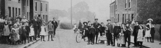
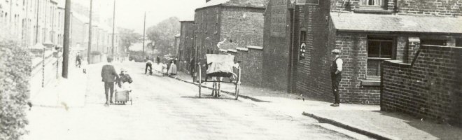
The Turnpike Trustees, who met at the George Hotel, Alfreton, made use of these provisions, and instead of following the road along its original course via Birchwood, decided to construct a new highway from Flowery Leys Lane, over Somercotes Common, directly to join the old road at the Black Horse Inn. This one single decision effectively created the opportunity for the development of land situated adjacent to the new road over Somercotes Common, which initially became known as Upper Somercotes, before it became the centre of the village in the mid to late 1800s.
Further Acts of Parliament were enacted throughout the following years to create a network of roads in the district (see separate Article on the Alfreton Inclosures).
The Trustees were able, under the Act of Parliament, to charge a toll for using the highway. They did this by leasing out the right to charge the tolls, although the charges and rules were strictly enforced by Parliament. Such leases were auctioned locally. A toll gate existed at the end of Flowery Leys Lane, Alfreton, and also near the Black Horse Inn at Lower Somercotes.
Following is an extract from a Notice regarding a meeting of the Alfreton Turnpike Trustees where an auction of Tolls took place. It was published in the Derbyshire Times and Chesterfield Herald dated 23 September 1874.
"Alfreton and Derby and Alfreton, Higham and Tibshelf Turnpike Roads
Notice is hereby given that meetings of the Trustees of the above mentioned Turnpike Roads will be held at the George Hotel, Alfreton in the County of Derby on Thursday the 22nd day of October next at 12 o’clock at noon for general purposes, and at the said meetings the Tolls arising at the Toll Gates and Chains upon the said roads respectively will be let by auction to the best bidders for a term of one year to commence on the 1st day of January 1875 in the manner directed by several Acts of Parliament, passed and now in force… (The Notice carries on at this point)
Josh. Geo. Wilson
Clerk to the Trustees of the said Roads. Alfreton 21st September 1874".
By the time the above Notice had appeared in the Derbyshire Times, many Turnpike Trusts had ceased operation. The turnpikes were becoming a problem for the industrialists who saw them as an obstacle to free trade. Combined with the effect of the expanding railway network, many Turnpike Trusts would close long before the Alfreton Trust.
When Derbyshire County Council was formed in 1889, (under the Local Governments Act of 1888), it took over the management of the road system, and in turn Alfreton Urban District Council became responsible for the upkeep of the Alfreton-Mansfield and Alfreton-Nottingham Turnpike Roads, at least up to the County border, although tolls were no longer being charged.
Although the history of the road numbering system commonly used today is a little complicated, the main “A” roads were developed from around 1920, and part of the original turnpike road which ran from Alfreton to Watnall, a distance of some 12.1 miles, was designated the A613. This was still the same road that ran through Somercotes and Pye Bridge and was locally named “Nottingham Road”, “Somercotes Hill” and “Main Road, Pye Bridge”.
The construction of the M1 Motorway, particularly with its junctions close to Watnall and Alfreton, changed the level of traffic on the A613 and around 1970 the Department of Transport decided to downgrade the road and changed its designation to the B600.
It remains the B600 to this day.